Solo Training
We have several maps and courses to help with training. All the maps on this page are on public land around Wellington so you can train using these maps at any time, except once an event has been scheduled in the location.
Some maps from previous events can also be found in the Events and Results pages, but are not updated as the terrain changes and may not be on public land. You can use the Herenga a Nuku (Outdoor Access Commission) Maps to determine access to a particular map.
Please take care, let someone know where you’re going and when you will be back, and don’t take any unnecessary risks. We cannot provide certainty of the condition of the terrain at all times, so use of these maps is at your own risk.
If you encounter any issues or safety hazards whilst running on any of these maps then contact us
MapRun
The simplest way to train on the maps below is to download the PDF file, print it using a colour printer, and take it for a run. However, there are no markers at the control site to give you confidence you’re in the right place (unlike with our Permanent Courses).
MapRun can enhance your training by giving you “virtual feedback” that you’re in the right place. By installing the MapRun app on your phone and/or Garmin watch and loading the course, the app can be set to vibrate when you reach the control site. It can also be used to track your training, and time your progress between controls - just like a real orienteering event!
More detail on using MapRun can be found at the links below:
- A brief introductory video is here: https://www.facebook.com/watch/?v=2549947025312165
- A brief text introductory guide is here: https://maprunners.weebly.com/quick-guide.html
MapRun will be available with some of the training maps in the near future.
Te Ahumairangi (Tinakori Hill)
Created: 2020
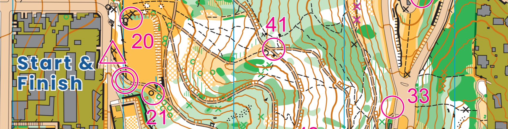
This is a traditional point-to-point course. There are two versions of the same course, depending on whether you start above Wadestown (Course 1N) or Northland (Course 1S). Controls are marked by tapes.
Access
From Wadestown, head to the top of Weld Street. If coming by car, approach from the west side of Wade Street. Head up from the first carpark and swing hard left to the higher carpark at the north end of Te Ahu Mairangi.
From Northland, park along Orangi Kaupapa Road between the entrance to Stellin Memorial Park and Bedford Street. Walk up the Te Ahu Mairangi service road to the start.
Lion’s Roar
Created: 2020
This was a mini-rogaine in 2017. Use the map and question-and-answer sheet to decide if you are at the right place - there are no tapes or controls. However, some things may have changed since 2017,so don’t worry if the control item is not obvious.A start/finish is marked on the map, but you may start and finish anywhere.
Access
The suggested start and finish is at Newtown Park. Parking and road access is from Russell Terrace in Berhampore.
Karori Park
Created: 2020
We suggest timing yourself to visit 10 controls in any order, starting from any sensible entry point from nearby roads. Start timing as you leave the roads or car park, and stop when you get to your final control. The walk off the map is not in “race” time.
Watch out for the very rough and frequently slippery tracks in Karori Park.
There are two versions of the map in the linked PDFs - one with tracks marked on the map, and one without.We suggest the “TRACKLESS” version only be used by those who have used Karori Park often and seek an unusual challenge! You’ll still be using tracks mostly, as off-track vegetation can be variable, but will have to use the contours to work out where your tracks are leading you, and no guarantees a track will go where you want.
Download the Karori park map with no tracks
Access
From Karori, access from Montgomery Avenue, Percy Dyett Drive, or Sunshine Avenue.
Trelissick Trails
Created: 2020
This is mostly a simple trail run on a preliminary map put together as a Covid-19 lockdown project. Don’t expect our usual mapping quality! This is a score-like offering, with instructions on the map if you want to generate a score.
There are two types of controls - those at the centre of circles as usual and ones marked by a magenta line along a track. The magenta line controls should be obvious from the track, but don’t worry if you pass them by. If you see them, try and identify exactly where on the track they are from the contour features around you.
You can start and finish anywhere. If you time yourself, note the time from the first to last control. Controls are marked by bright orange or yellow tapes. Only a couple of controls are not immediately visible from a track, and you need go no nearer to the tape than being able to see it.
Download the Trelissick park map
Access
From Ngaio/Kaiwharawhara, use the entrances on Kaiwharawhara Road, Ngaio Gorge Road, Trelissick Crescent or Waikowhai Street. From Wadestown, enter from Hanover Street.
Hutt Valley options
Orienteering Hutt Valley offers a selection Anytime Orienteering courses. These too are free, DIY courses that you may wish to give a go.