Event planning
Wellington Event Planning - What to do
These guidelines will give you an idea of the process of planning an orienteering event for Orienteering Wellington.
The full rules for planning orienteering events can be found in the NZ Orienteering Competition Rules. This page focuses on detail specific to Wellington (what types of events occur in Wellington, processes and timelines etc.)
What courses and how long should they be?
Course difficulty
The following course definitions are from the Orienteering NZ FAQ:
- White Course: Courses follow drawn linear features (tracks, fences, streams, distinct vegetation boundaries, etc.). Compass use is limited to map orientation only.
- Yellow Course: Control sites on or near (<50 m) drawn linear features (tracks, fences, streams, distinct vegetation boundaries, etc). This gives the opportunity to follow handrails or to cut across country (i.e. limited route choice). Compass use is limited rough directional navigation. Contour recognition is not required for navigation but simple contour features may be used for control sites.
- Orange Course: Courses have route choice with prominent attack points near the control sites and/or catching features less than 100 m behind. Control sites may be fairly small point features and the control markers need not necessarily be visible from the attack point. Simple navigation by contours and rough compass with limited distance estimation required.
- Red Course: Navigation is as difficult as possible with small contour and point features as preferred control sites (no obvious attack points, no handrails etc.). Route choice is an important element in most legs.
- Red Short courses should be technically but not physically challenging. Ideally they (along with the Orange, Yellow and White courses) will be on a larger-scale (zoomed-in) map to aid with legibility.
- Red Long courses should be both technically and physically challenging.
Course lengths
A good way to work out an appropriate course length is to search Winsplits and Routegadget for events on that map on previous years. The example below suggests a course at Mill Creek of 4.2km is very slightly short. Obviously differences in climb and vegetation on the course will mean this is only a rough guide.
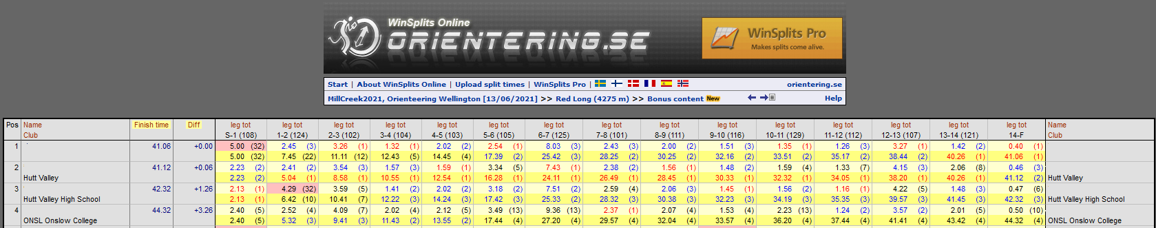
The winning time will also depend on who runs the course. You should set the course to have the given winning time based on who you would expect to run that course.
As a rough guide, you could expect :
- Red long: experienced M/W21 runners
- Red medium: experienced M/W50
- Red short: experienced M/W60+
- Orange is difficult because it attracts a mix of abilities, but aim for a winning time you would expect for a 13-14 year-old who is confident with navigation using big contours and other large features. This course also tends to attract adventure racers.
- Yellow: A 10 year-old who is confident navigating to large features away from paths or tracks.
- For white, expect young children (5+) with their parents; winning time would be based on a 7-8 year old.
Wellington event types
College Sport Wellington (CSW) weekend events
CSW events tend to have the following courses: Red Long, Red Medium, Red Short, Orange, Yellow, White. In some cases, such as where the map is small, it may make sense to not have a Red Long.
Generally, you want the winning time of orange and red courses to be around 45 minutes (give or take a bit). The yellow and white courses should have a winning time of 20-30 minutes.
CSW requires us to relate a Course (red, yellow etc.) to an age class (e.g. M16). The below is an example of the Classes used in CSW and how they relate to a course:
| Grade | School Year | Championship | Standard | Novice |
|---|---|---|---|---|
| Senior | 12 & 13 | Difficult (Red) | Medium (Orange) | Easy (Yellow) |
| Intermediate | 10 & 11 | Medium (Orange) | Easy (Yellow) | |
| Junior | 9 | Easy (Yellow) | Very Easy (White) |
CSW Sprint
CSW Sprint events generally have a Red Long, a Red Medium, and a Short course.
The Red Long course should be technically challenging (Red) and aim for a winning time of 15 minutes for an M18.
- Senior Boys will run this course.
The Red Medium course should be technically challenging (Red) and be 80% the length of the Red Long (15 minutes for a W16).
- Senior Girls, Intermediate Boys and Intermediate Girls will run this course.
The Short course should be easy to moderately challenging (Yellow/Orange) and aim for a winning time of 15 minutes for M12A.
- Junior Boys and Girls will run this course.
Orienteer of the Year (OY)
The OY series is a regional competiton made up of six events anually and is organised by Orienteering Wellington, Red Kiwi and Hutt Valley.
OY courses are intended to challenge competitors more than at a regular club event, and a ranking system is in place to generate some competition across the events.
OY events have the following courses (winning time):
- Red Long (65 mins)
- Red Medium (50 mins)
- Red Short (40 mins)
- Orange Long (45 mins)
- Orange Short (30 mins)
- Yellow (25-30 mins)
- White (20-30 mins)
If the OY is combined with a CSW, the most difficult course for CSW competitors should be Red Medium, and other CSW classes should be scaled appropriately.
Afterwork club events
Low key events, such as the Spring Series (which are Wednesday evening events) tend to just have two courses, a long and a short. The long would be around a 30-minute Red, and the Short would be between a Yellow and an Orange.
Weekend club events
Weekend club events should have the following courses: Red Long, Red Medium, Red Short, Orange, Yellow, White. In some cases, such as where the map is small, it may make sense to not have a Red Long. Generally, you want the winning time of orange and red courses to be around 45 minutes (give or take a bit). The yellow and white courses should have a winning time of 20-30 minutes.
Score events
Score events are a little different as each control is assigned a number of points depending on its difficulty and competitors must try to get as many points as possible in the available time. Wellington Score events are generally 60 minutes long.
What do I actually do?
6-3 weeks before the event
Request the map file from the Mapping Officer
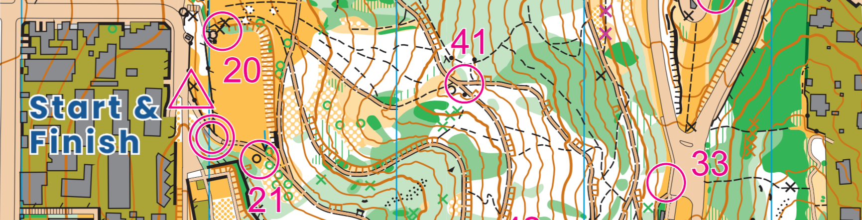
Roughly plan the courses on paper or on your computer;
Visit the map and check out your control sites, obvious attack points and the quality of the map between the attack point(s) and the control sites;
Check the junior courses in their entirety – the younger and less experienced people are less able to cope with a mismatch between map and ground or dangerous areas;
Provide the permissions officer with a map showing the rough course extents and noting any specific hazards so they can add them to the HARM form.
3-2 weeks before the event
- Send draft courses to the Controller and make any changes they suggest from their review;
- Send event details to the Event Coordinator (parking, course lengths, climb, no. controls) for the ONZ website
- Provide the permissions officer with a draft All Controls map so they can send it to the landowner.
- Send the list of courses and classes to the IT officer so he can publish the pre-entry registration page.
A week before the event
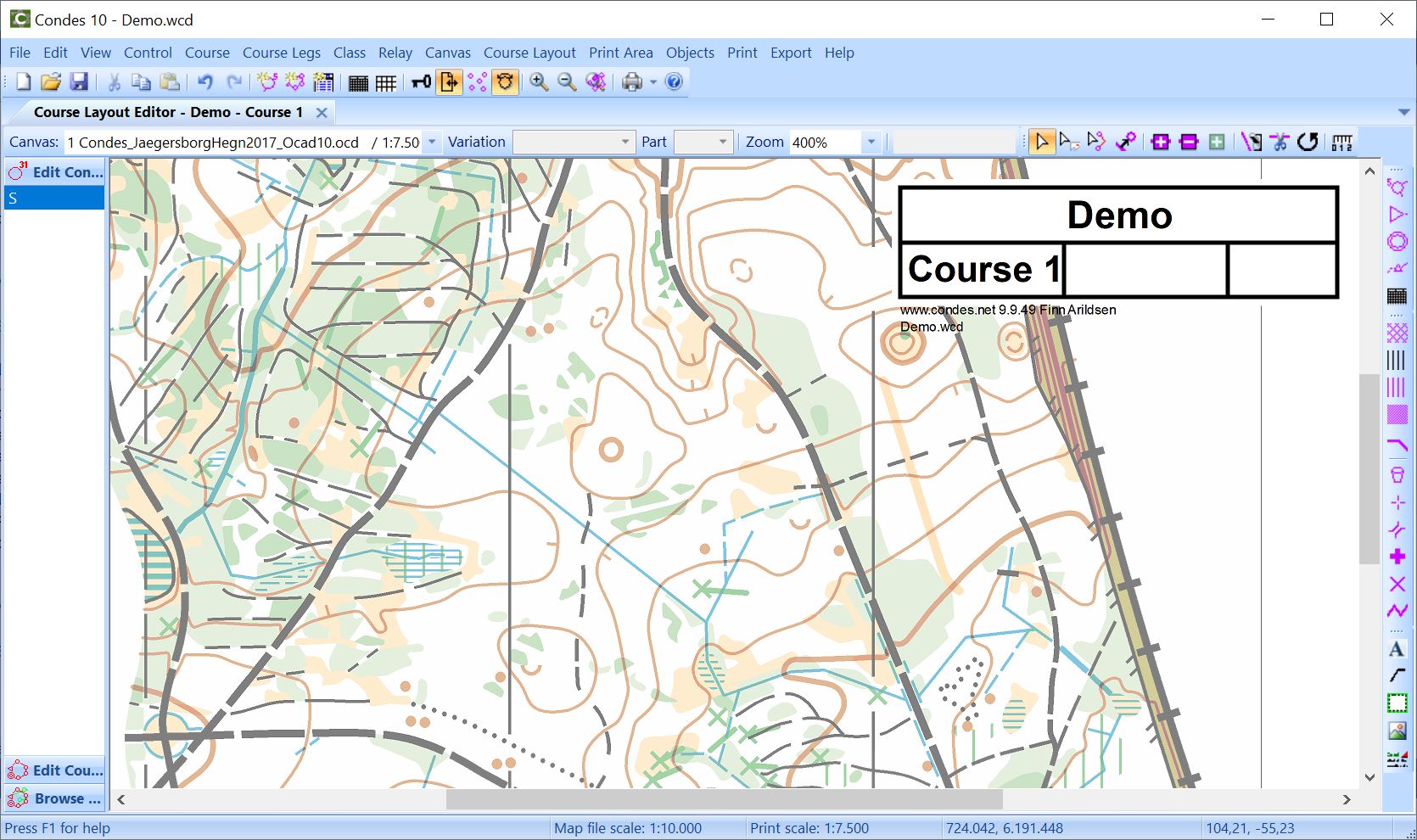
Ensure your courses are tidied up in Condes - numbers and control circles clear and not obscuring important features; control descriptions produced on the map correctly; scale bar added.
Use the ONZ MapFramer to add fancy borders to your maps. A written guide as well as a video are available on how to use it.
Graphics for use on the map such as scale bars, north arrows and legends can be found in this Google Drive folder
- Send the course XML file and the final maps in pdf format to the Equipment Officer at least 5 days before the event;
- Work with the controller on a plan for making sure controls go in the right place;
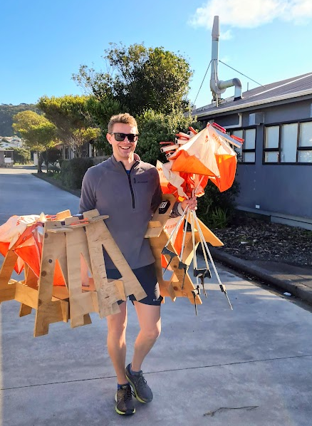
- Organise to collect the controls, tapes and any other gear you need from the Equipment Officer
- Print out lists of the classes/courses to help with registration. You can use the Event Information Notice template to help with this.
On the day (or the day before)
- Set out controls (agree when with the controller);
- Be around on the day of the event for the whole event.
After the event
- If you have updated the map (.ocd file), send the updated map file to the Mapping Officer
- Consider uploading the event to Routegadget so that competitors can share their routes and learn from others. Speak to the Event Coordinator for details on how to do this.
Who will help me?
The controller
Along with your role as the course planner, a controller will be appointed. The controller’s role is to be responsible for the final quality and safety of the courses. They will inevitably have suggestions and requirements which change your courses. Don’t be offended by this – it is surprising how useful it is to have a fresh pair of eyes glance over a set of courses.
The controller is usually very experienced, and usually they see things in a different way to you. Between you and the controller, you are trying to set challenging and enjoyable courses.
Other contacts
See the committee page for contact details.
- The events coordinator can put you in touch with other key people including:
- The landowner liaison person, who will work with you to arrange access to any private land in the event;
- The mapping officer, who will provide the map to plan on, and a form of the map with scale and legend for printing;
- equipment officer for checking available control numbers (typically from 101 upwards) and map printing.
- There will also be somebody organising helpers on the day.
What do I need?
A current version of the course planning software, Condes. Download from http://www.condes.net/index.php/download/
We have a club license for Condes version 10. You need the following to register the copy you download to gain full access:
- Club: Wellington Orienteering Club
- Code: Contact the events coordinator
We can provide guidance on Condes use.
A copy of the map (typically in .ocd format) that will open in Condes; We suggest printing a couple of copies of the map to do your initial sketching of courses.
Time – it takes time to get courses right.